 学院介绍
学院介绍
新闻中心


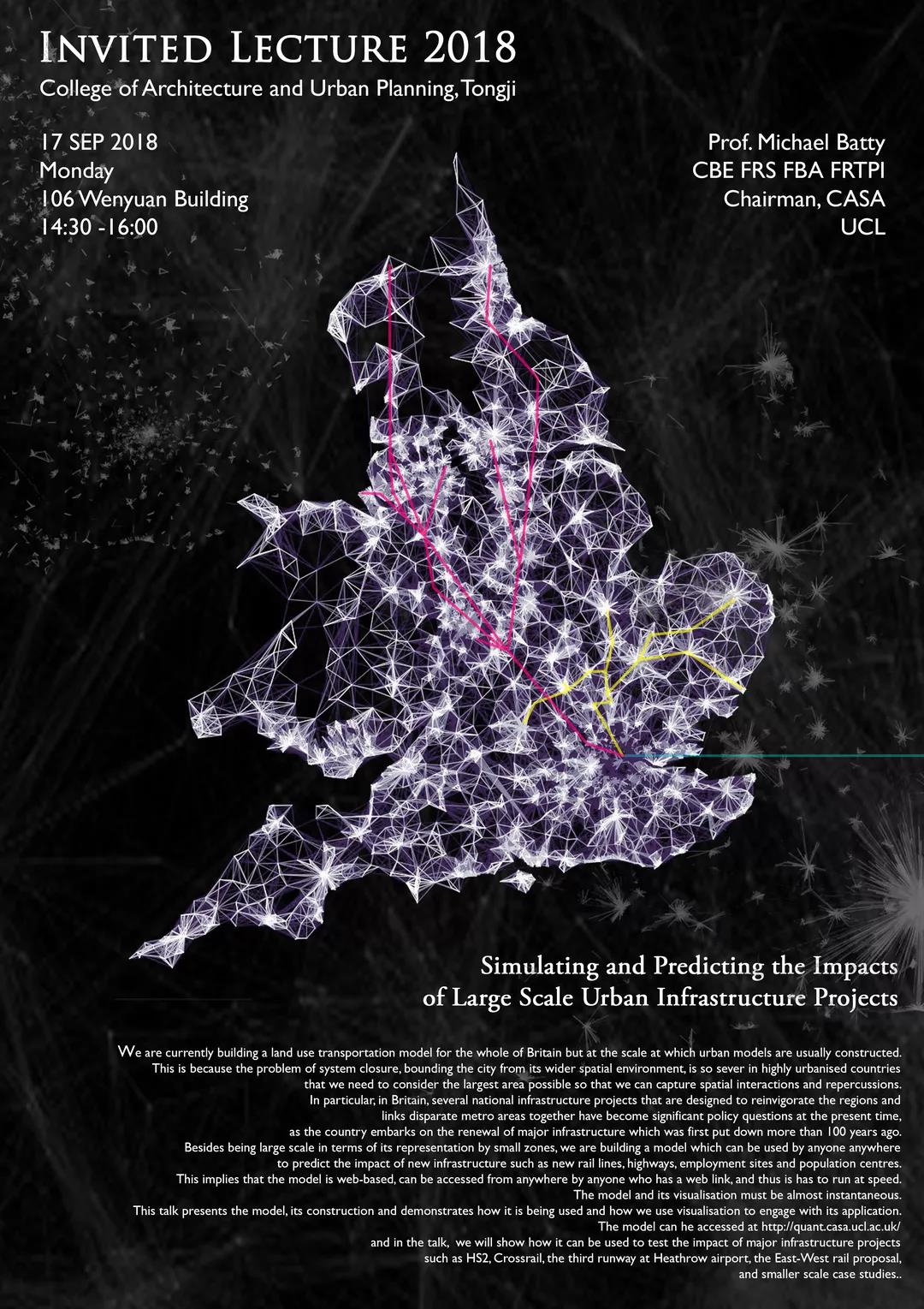
Simulating and Predicting the Impacts of Large Scale Urban Infrastructure Projects
Michael Batty
Abstract:We are currently building a land use transportation model for the whole of Britain but at the scale at which urban models are usually constructed. This is because the problem of system closure, bounding the city from its wider spatial environment, is so sever in highly urbanised countries that we need to consider the largest area possible so that we can capture spatial interactions and repercussions. In particular, in Britain, several national infrastructure projects that are designed to reinvigorate the regions and links disparate metro areas together have become significant policy questions at the present time, as the country embarks on the renewal of major infrastructure which was first put down more than 100 years ago. Besides being large scale in terms of its representation by small zones, we are building a model which can be used by anyone anywhere to predict the impact of new infrastructure such as new rail lines, highways, employment sites and population centres. This implies that the model is web-based, can be accessed from anywhere by anyone who has a web link, and thus is has to run at speed. The model and its visualisation must be almost instantaneous. This talk presents the model, its construction and demonstrates how it is being used and how we use visualisation to engage with its application. The model can he accessed at http://quant.casa.ucl.ac.uk/ and in the talk, we will show how it can be used to test the impact of major infrastructure projects such as HS2, Crossrail, the third runway at Heathrow airport, the East-West rail proposal, and smaller scale case studies.

Professor Michael Batty
Michael Batty,博士,英国伦敦大学学院(UCL)Bartlett教授、高级空间分析中心(CASA)主席,先后当选英国皇家艺术学会会士(fellow)(1982),社会科学院(Academy of Social Sciences)院士(2001),英国国家学术院(British Academy)院士(2001),英国皇家学会院士(fellow)(2009)。自1970年来一直致力于城市地理的计算机模型及其可视化分析,先后担任英国威尔士大学卡迪夫分校城市规划教授、院长,美国纽约州立大学布法罗分校国家地理信息分析中心主任。鉴于在城市地理科学的杰出工作,2004年被英国女皇授予大英帝国司令勋章,2013年被授予Lauréat Prix International de Géographie Vautrin Lud(被誉为地理学界的诺贝尔奖),2015年被地理科学皇家协会被授予“创始人奖章”。
Michael Batty is Bartlett Professor of Planning at University College London where he is Chair of the Centre for Advanced Spatial Analysis (CASA). He has worked on computer models of cities and their visualisation since the 1970s and has published several books, such as Cities and Complexity (MIT Press, 2005) and The New Science of Cities (MIT Press, 2013). His most recent book Inventing Future Cities will be published by MIT Press in late 2018. His blogs www.complexcity.info cover the science underpinning the technology of cities and his posts and lectures on big data and smart cities are at www.spatialcomplexity.info. Prior to his current position, he was Professor of City Planning and Dean at the University of Wales at Cardiff from 1979 to 1990 and then Director of the National Center for Geographic Information and Analysis at the State University of New York at Buffalo (1990-1995). He is a Fellow of the British Academy (FBA) and the Royal Society (FRS), was awarded the CBE in the Queen’s Birthday Honours in 2004 and the 2013 recipient of the Lauréat Prix International de Géographie Vautrin Lud. In 2015 he received the Gold Medal of the Royal Geographical Society for his work on the science of cities. In 2016, he received the Senior Scholar Award of the Complex Systems Society and the Gold Medal of the Royal Town Planning Institute.
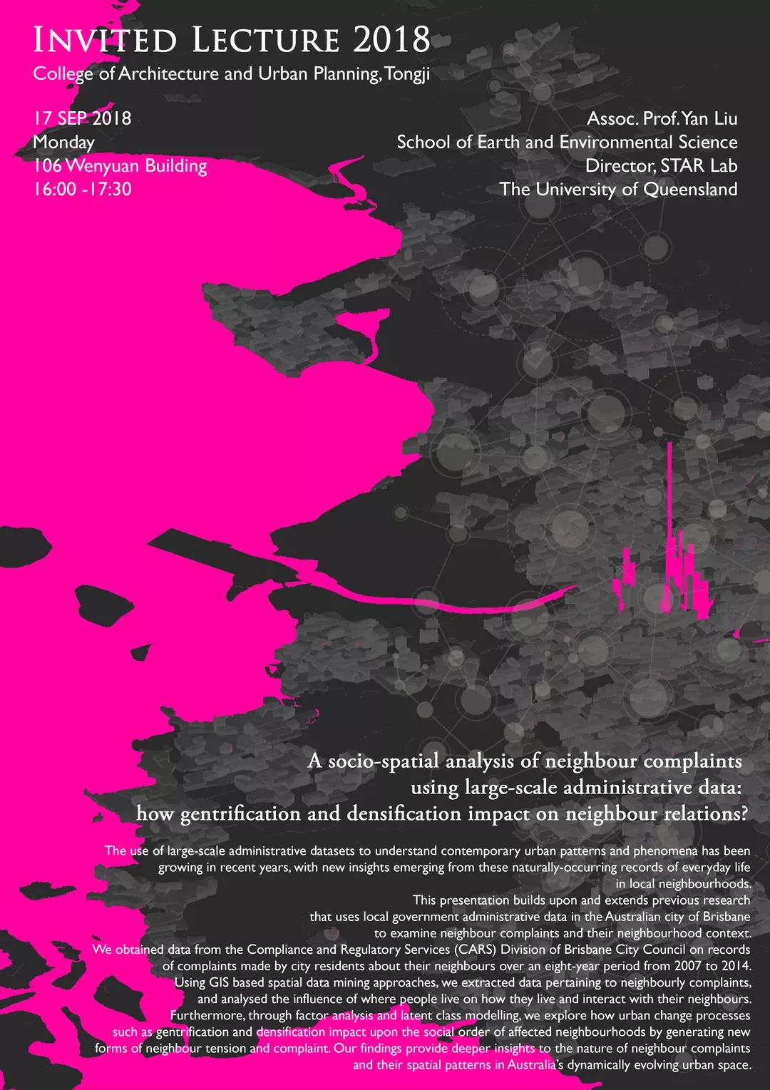
Neighbour relations in the changing urban space: an integrated socio-spatial approach using large scale administrative data
Yan Liu
Abstract:The use of large-scale administrative datasets to understand contemporary urban structure and change has been growing in recent years, with new insights emerging from these naturally-occurring records of everyday life in local neighbourhoods. This presentation builds upon and extends previous research that uses local government administrative data in the Australian city of Brisbane to examine neighbour complaints and their neighbourhood context. We obtained data from the Compliance and Regulatory Services (CARS) Division of Brisbane City Council on records of complaints made by city residents about their neighbours over an eight-year period from 2007 to 2014. Using GIS based spatial data mining approach, we extracted data pertaining to neighbourly complaints, and analysed the influence of where people live on how they live and interact with their neighbours. Furthermore, through factor analyses and latent class modelling, we explored how urban change processes such as gentrification and densification impact upon the social order of affected neighbourhoods by generating new forms of neighbour tension and complaint. Our findings provide deeper insights to the nature of neighbour complaints and their spatial patterns in Australia’s dynamically evolving urban space.

Professor Yan Liu
刘艳,副教授,澳大利亚昆士兰大学地球与环境科学学院地理信息科学专业博士导师,昆士兰大学时空分析研究室(Spatio-Temporal Analytics Research Laboratory – STAR Lab)主任,昆士兰大学社会科学研究所(ISSR)研究员,是国际地理科学核心期刊《Environment and Planning B: Urban Analytics and City Science》及《Journal of Spatial Science》的编委,上海市地理教育教学研究基地兼职教授。曾担任国际华人地理信息科学学会(GPGIS)主任委员、澳大利亚昆士兰华人科学家与工程师协会(QCASE)副主席及执行委员等职。主要研究包括元胞自动机及基于代理的城市空间发展模拟研究,地理信息大数据挖掘,空间分析及GIS在人文与社会科学中的应用研究。学术成果包括一部专著《基于地理信息系统和元胞自动机的城市发展模型》(由Taylor & Francis 出版集团出版),并在国际学术期刊上发表论文60余篇,多项研究获得澳大利亚国家科研基金委、昆士兰州政府、铁拓等的资助。
Yan Liu is an Associate Professor in Geographical Information Sciences at the University of Queensland. She runs the Spatio-Temporal Analytics Research Laboratory (STAR Lab). Yan’s research focuses on GIS, spatial analysis and modelling. She develops and applies cellular automata and agent based models to describe, understand, simulate and predict urban and human change dynamics and processes. She also develops spatially integrated analytical and modelling approaches for applications in the social and behaviour sciences. Her research is supported by the Australia Research Council (ARC) and other funding sources. She is an Affiliate Academic at the Institute for Social Science Research of the University of Queensland and an Adjunct Professor of Shanghai Geography Education and Teaching Research Base. She is a board member of the journal Environment and Planning B: Urban Analytics and City Science, and one of the editors of the Journal of Spatial Science.


