 学院介绍
学院介绍
新闻中心


校园图像感知分析
人工智能| 线下工作营 | 中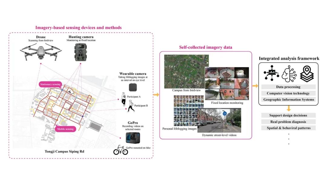
主题
深度学习技术的快速发展和计算机视觉的高效率广泛地促进了城市研究的许多方面,近年来基于图像数据的新兴城市分析不断涌现,如量化测度城市设计质量、可步行性、可骑行性、公共场所的受欢迎程度、个人接触绿色植物的暴露程度、个人屏幕使用模式等等。为了实现更高精度的研究,需要收集更加精细、实时和完整的数据。本次工作坊旨在利用多维度自采集的图像数据、GIS和深度学习技术,对同济校园进行科学的探索分析。
内容
工作坊主要基于图像数据,这些数据将由学生在现场调查中自行收集。通过运用GoPro(移动感知)、可穿戴相机(移动/固定混合感知)、狩猎相机(固定感知)、无人机(空中感知)和其它可能的传感器,学生可以探索固定感知和移动感知方法的应用。我们鼓励学生专注于与同济校园建成环境或者日常活动相关的研究课题。
成果
工作坊将以深度学习和机器学习框架为引导,结合几个案例研究和实践,让学生掌握系统化的研究方法,包括数据收集、数据清洗、计算机视觉方法、统计建模和空间分析。学生将以小组方式进行工作,最终的成果将以视频文档和演示的形式呈现。
所需技能
具备中等水平的GIS知识,基本的Python编程知识
所需软件
GIS (QGIS, ARCGIS), Python (Visual Studio Code, Anaconda, Jupyter Notebook, etc.) , ML / DL framework (Scikit-learn / Pytorch or Tensorflow)
所需硬件
笔记本电脑(windows 10系统)/ MAC
人数限制
线下20人
日程安排
DAY 1
2023/6/25
PART 1 教学:a. 介绍工作坊主题b. 图像感知案例研究 - 文章分享:“Measuring visual quality of street space and its temporal variation: Methodology and its application in the Hutong area in Beijing” - 文章分享:“Assessing personal exposure to urban greenery using wearable. cameras and machine learning”c. 可能研究主题的灵感
PART 2 制作:a. 破冰/团队建立(建议每组4名学生)b. 使用无人机进行数据收集(导师演示和收集数据,并将数据分享给学生)
DAY 2
2023/6/26
PART 1 教学:a. 图像传感设备的介绍和手册分发(狩猎相机/ GoPro/ 可穿戴相机)b. Python环境部署c. 深度学习和计算机视觉的介绍-背景/理论/当前应用-使用Python进行图像数据处理的演示和练习-将GIS信息与图像数据关联并使用GIS/Python进行练习-技术支持
PART 2 制作:团队确定研究主题和团队数据收集
DAY 3
2023/6/27
PART 1 教学:空间分析方法的介绍-GIS的演示和练习-使用Python进行机器学习和建模的演示和练习-技术支持
PART 2 制作:团队数据收集/团队研究开发
DAY 4
2023/6/28
团队研究开发/ 技术指导
DAY 5
2023/6/29
团队研究开发/ 技术指导
DAY 6
2023/6/30
PART 1:团队研究开发/ 技术指导
PART 2:小组讨论和展示
导师团队
龙瀛Ying Long
Tsinghua University,
Associate Professor
龙瀛,清华大学建筑学院研究员/长聘副教授/博导,主要从事城市科学研究,包括应用城市建模、城市大数据分析与可视化、定量城市研究、规划支持系统、数据增强设计和未来城市等方向。他的教育背景涵盖了环境工程和城市规划两个领域。在加入清华大学之前,他曾在北京市规划设计研究院工作了十一年,担任高级规划师。他熟悉中国的规划实践,也通晓国际文献,他的学术研究创造性地将国际方法和经验与本土规划实践相结合。他已经发表了近两百篇论文,并主持了二十多个研究/规划项目。他的资助项目涉及世界银行、世界卫生组织、世界资源研究所、自然资源保护委员会、惠康基金会等国际组织,阿里巴巴、百度、京东、腾讯、滴滴、摩拜和谷东等互联网公司,北京、成都、青岛、合肥、遵义、荣成和莱州等地方政府,以及国家发改委、住建部和国家自然科学基金等中央政府部门。他还是北京城市实验室(BCL www.beijingcitylab.com)的创始人,这是一个开放的定量城市研究网络。更多详见http://www.beijingcitylab.com/longy。
Ying Long, Ph.D. is now working in the School of Architecture, Tsinghua University, China as a tenured associate professor. His research focuses urban science, including applied urban modeling, urban big data analytics & visualization, quantitative urban studies, planning support systems, data augmented design and future cities. He has an education background in both environmental engineering and city planning. Before joining Tsinghua University, he has worked for Beijing Institute of City Planning as a senior planner for eleven years. Familiar with planning practices in China and versed in international literature, Dr. Long’s academic studies creatively integrate international methods and experiences with local planning practices. He has published almost two hundred papers and led over twenty research/planning projects. His funded projects range from international organizations like World Bank, World Health Organization, World Resource Institute and NRDC, and Wellcome Trust, internet companies like Alibaba, Baidu, Jingdong, Tencent, Didi, Mobike and Gudong, local governments like Beijing, Chengdu, Qingdao, Hefei, Zunyi, Rongcheng and Laizhou, to central governments like NDRC and MOHURD, and the NSFC. Dr. Long is also the founder of Beijing City Lab (BCL www.beijingcitylab.com), an open research network for quantitative urban studies. More information is available at http://www.beijingcitylab.com/longy.
苏南西Nanxi Su
Tsinghua University,
PhD student
苏南西(Nanxi Su)目前就读于清华大学,攻读城乡规划学博士学位。本科毕业于同济大学,硕士研究生毕业于哥伦比亚大学。曾在中国、美国知名建筑事务所实习和工作。她目前主要的研究方向为城市空间品质,研究成果曾发表于Habitat International等国际期刊。
Nanxi Su is currently pursuing a doctoral degree in urban and rural planning at Tsinghua University. She graduated from Tongji University with a bachelor’s degree and from Columbia University with a master’s degree. She has interned and worked at well-known architectural firms in China and the United States. Her current main research direction is urban spatial quality, and her research results have been published in international journals such as Habitat International.
张业成
Yecheng Zhang
Tsinghua University,
PhD student
张业成(Yecheng Zhang)目前于清华大学城乡规划学直博。本科毕业于合肥工业大学。目前主要的研究方向为城市科学,研究成果曾发表于INT J APPL EARTH OBS等国际期刊。
Yecheng Zhang is currently pursuing a direct doctoral degree in urban and rural planning at Tsinghua University. He graduated from Hefei University of Technology with a bachelor’s degree. His current main research direction is urban science, and his research results have been published in international journals such as INT J APPL EARTH OBS.
案例
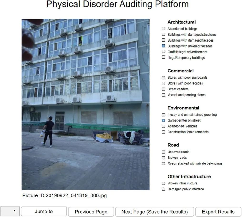
1. 利用可穿戴式相机测度基于个体移动性的建成环境失序暴露
Individuals’mobility-based exposure, Neighborhood physical disorder and Wearable cameras
研究提出用穿戴式相机测度考虑个体移动性的建成环境暴露测度方法,帮助研究者更准确地评估个体在时空活动中的暴露情况。
This study assessed individual exposure to neighborhood physical disorder through the mobility-based approach using wearable cameras. The use of this approach allowed us to leverage innovative tools to accurately assess exposure to NPD in individuals’ activities in space-time.
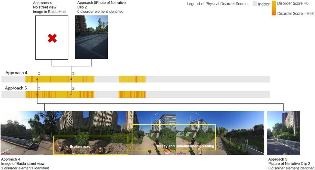
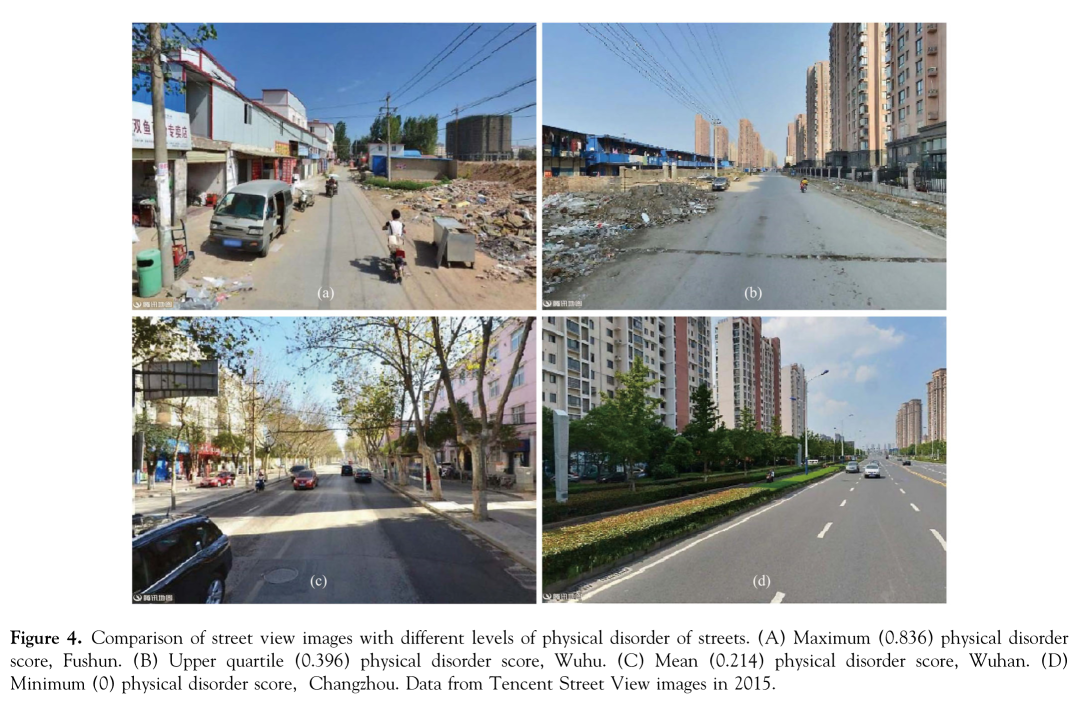
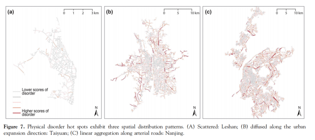
2. 城市街道空间失序的测度:基于街景图像和深度学习的大规模分析
Physical Disorder, Urban Street Spaces and Deep Learning
研究提出一种有效、可复制和低成本的方法来评估大范围的城市空间失序。以海量街景图像作为虚拟核查的输入数据, 利用深度学习模型定量评估城市街道空间失序,并在中国70多万条城市街道上实现了这一方法。
This study proposes an approach that takes advantage of the massive volume of street view images as input data for virtual audits and uses a deep learning model to quantitatively measure the physical disorder of urban street spaces. The results of implementing this approach with more than 700,000 streets in Chinese cities.
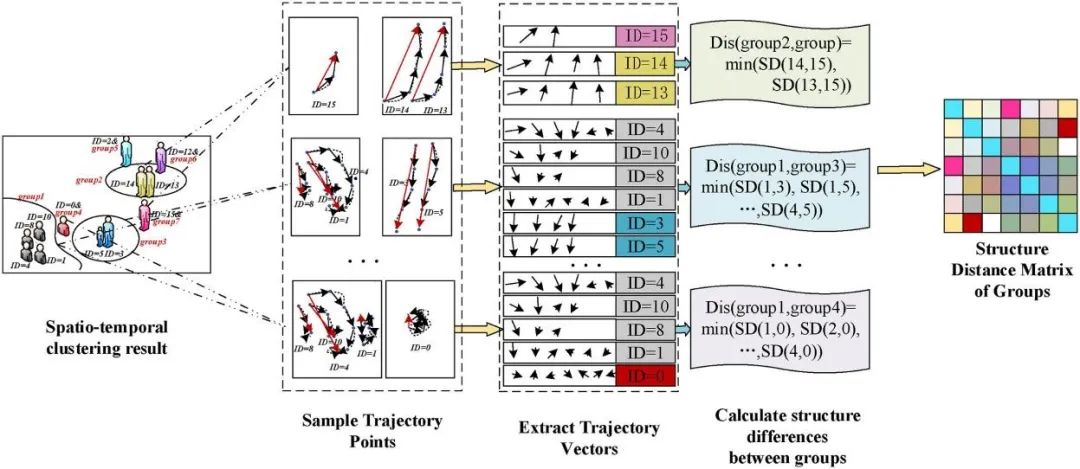
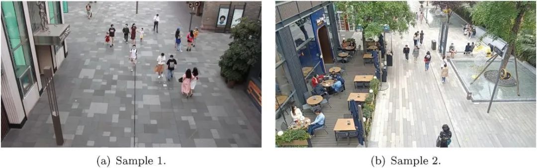
3. 基于视频数据的人群轨迹对小型公共空间活力分析与评价使用的建模
Small Public Space Vitality, Human Trajectory Modeling and Video Data
以往基于低样本量调查或低定位精度大数据的活力研究,并不适合小公共空间的高效率研究。在这项研究中,一个小型公共空间活力量化的系统框架建立在从视频中提取的细粒度人群轨迹上,以便进行更高效和更精细的以人为本的活力评估。首次提出一种多指标活力量化方法,综合表征人群活力,包括人数、停留时长、运动速度、轨迹多样性和轨迹复杂度。此外,还提出了一个小型公共空间视频数据集以及我们的子指标辅助专家评估方案,以评估我们的活力量化框架。
Previous studies of vitality based on low-throughput surveys or big data with low positioning accuracy are not suitable for the high-efficiency study of small public space. In this study, a systematic framework of vitality quantification in small public spaces is built on fine-grained human trajectories extracted from videos for more efficient and refined human-oriented vitality evaluation. A multi-indicator vitality quantification method is first proposed to comprehensively represent human vitality, including number of people, duration of stay, motion speed, trajectory diversity and trajectory complexity. Furthermore, a video dataset of small public space along with our sub-index-assisted expert assessing scheme is proposed to evaluate our vitality quantification framework.
4. 使用旋转移动监测和机器学习方法预测高动态交通噪声
Predicting highly dynamic traffic noise usingrotating mobile monitoring and machine learning method
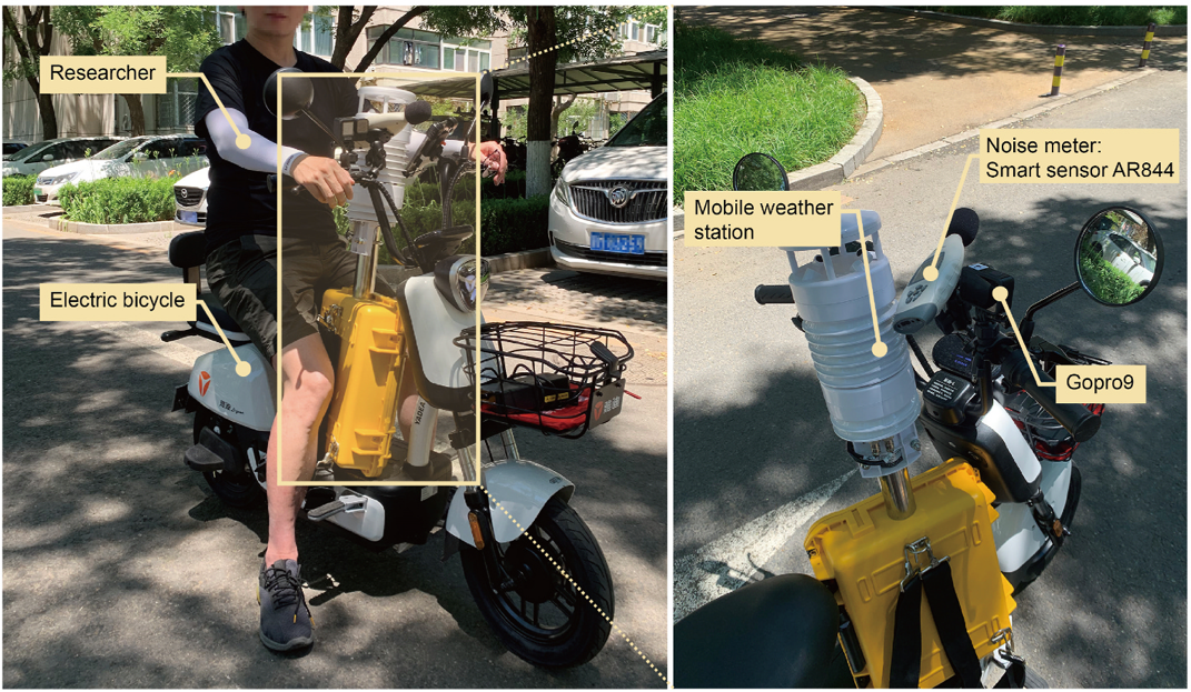
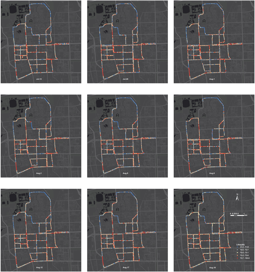
以高度波动性为特征的交通噪声是世界上第二大环境问题。高度动态的噪声地图对于管理交通噪声污染具有较高价值,但在创建这些地图时存在两个关键困难:缺乏大量精细的噪声监测数据和在没有噪声监测数据的情况下精准预测噪声水平的能力。本研究提出了一种新的噪声监测方法--旋转移动监测(或称为重复固定监测)法,它结合了固定和移动监测方法的优点,扩大了噪声数据的空间范围和时间分辨率。本研究在北京海淀区进行了一次监测活动,覆盖了54.79公里的道路和22.15平方公里的总面积,从152个固定采样点收集了18213个1s间隔的A加权等效噪声(LAeq)测量值。此外,还从所有移动监测道路和固定地点收集了街景图像、气象数据和建筑环境数据。使用计算机视觉和GIS分析工具,在四个类别中测量了49个预测变量,包括微观交通组成、街道形式、土地利用和气象。训练了六个机器学习模型和线性回归模型来预测LAeq,其中随机森林模型表现最好(R2 = 0.72,RMSE = 3.28 dB),其次是K-近邻回归模型(R2 = 0.66,RMSE = 3.43 dB)。最佳的随机森林模型确定了到主要道路的距离、街道绿视率指数和过去3秒内汽车的最大视野比例为排名前三的贡献因素。最后,该模型被应用于生成研究区域的点和街道层面的9天交通噪声地图。该研究很容易复制,可以扩展到更大的空间范围,以获得高度动态的噪声地图。
Traffic noise, characterized by its highly fluctuating nature, is the second biggest environmental problem in the world. Highly dynamic noise maps are indispensable for managing traffic noise pollution, but two key difficulties exist in generating these maps: the lack of large amounts of fine-scale noise monitoring data and the ability to predict noise levels in the absence of noise monitoring data. This study proposed a new noise monitoring method, the Rotating Mobile Monitoring method, that combines the advantages of stationary and mobile monitoring methods and expands the spatial extent and temporal resolution of noise data. A monitoring campaign was conducted in the Haidian District of Beijing, covering 54.79 km of roads and a total area of 22.15 km2, and gathered 18,213 A-weighted equivalent noise (LAeq) measurements at 1-s intervals from 152 stationary sampling sites. Additionally, street view images, meteorological data and built environment data were collected from all roads and stationary sites. Using computer vision and GIS analysis tools, 49 predictor variables were measured in four categories, including microscopic traffic composition, street form, land use and meteorology. Six machine learning models and linear regression models were trained to predict LAeq, with random forest performing the best (R2 = 0.72, RMSE = 3.28 dB), followed by K-nearest neighbors regression (R2 = 0.66, RMSE = 3.43 dB). The optimal random forest model identified distance to the major road, tree view index, and the maximum field of view index of cars in the last 3 s as the top three contributors. Finally, the model was applied to generate a 9-day traffic noise map of the study area at both the point and street levels. The study is easily replicable and can be extended to a larger spatial scale to obtain highly dynamic noise maps.
Workshop Admission
Campus Sensing - Powered by Multi-dimensional Imagery Data, GIS, and Deep Learning
Artificial Intelligence | Physical Workshop | CN
TOPIC
The rapid development of deep learning technology an d the high efficiency of computer vision have widely boosted urban studies in lots of aspects, and new kinds of urban analysis based on imagery data have populated in recent years, such as quantitatively measuring urban design quality, walkability, bikeability, popularity of public places, personal exposure to greenery, personal screen use patterns, etc. To accomplish research with higher accuracy, more granular, updated, and complete data should be collected. This workshop aims to explore Tongji campus with scientific analysis using multi-dimensional self-collected imagery data, GIS, and deep learning technology.
CONTENT
The workshop is largely based on imagery data which will be collected by students themselves from scratch during field investigations. With the application of GoPro (mobile sensing), wearable camera (mobile/ stationary hybrid-sensing), hunting camera (stationary sensing), drone (aerial sensing) and other possible sensors, students may explore stationary sensing and mobile sensing methods, or an integrated one. Students are encouraged to focus on research topics related to the built environment of Tongji campus, or to the everyday activities depending on their interests. The workshop will begin with an introduction to deep learning and machine learning framework, with a few case studies and practices for the students to grasp up a systematic research methodology covering from data collection, data cleaning, computer vision method, to statistical modeling and analysis. Students will work in teams and the final output of this workshop will be in the format of a video documentation and presentation.
REQUIRED SKILLS
Intermediate GIS, beginner Python
REQUIRED SOFTWARE
GIS (QGIS, ARCGIS), Python (Visual Studio Code, Anaconda, Jupyter Notebook, etc.) , ML / DL framework (Scikit-learn / Pytorch or Tensorflow)
REQUIRED HARDWARE
Laptop (Windows 10)/ MAC
NUMBER OF PARTICIPANTS
Maximum number of participating students: 20
Schedule
DAY 1
2022/6/25
Part 1 Tutorial: a. Introduction of workshop topicb. Imagery sensing case studies - Article sharing: “Measuring visual quality of street space and its temporal variation: Methodology and its application in the Hutong area in Beijing” - Article sharing: “Assessing personal exposure to urban greenery using wearable. cameras and machine learning”c. Inspiration of possible research topics
Part 2 Production:a. Icebreaking/ team setup (4 students per team suggested)
b. Data collection with drone (tutor will demonstrate and collect the data, and data will be shared to all students)
DAY 2
2022/6/26
Part 1 Tutorial:a. Introduction of imagery sensing devices & manual distribution (Hunting camera/ GoPro/ Wearable. camera)b. Python environment deploymentc. Introduction of deep learning & computer vision - Background/ theory/ current application - Imagery data processing demo & practice with Python - linking GIS information to imagery data & practice with GIS/python - Technical support
Part 2 Production:Team research topic development/ team data collection
DAY 3
2022/6/27
Part 1 Tutorial:
Introduction of spatial analysis methods - Demo & practice of GIS - Demo & practice of machine learning & modeling with python - Technical support
Part 2 Production:Team data collection/ team research development
DAY 4
2022/6/28
Team research development/ technical guidance
DAY 5
2022/6/29
Team research development/ technical guidance
DAY 6
2022/6/30
Part 1:Team research development/ technical guidance
Part 2:Presentation & discussion in groups
加入工作营
Join Us

更多工作营信息可访问:
www.digitalfutures.world/
*工作营面向海内外高校学生、高校教师学者、以及社会专业人士开放报名。本项目不收取任何费用,学生自行承担差旅和食宿。
准备工作
关注DigitalFUTURES微信公众号
关注DigitalFUTURES Instagram等网络媒体
获取各组工作营的导师及教学信息
1
注册账号
前往www.digitalfutures.world网站,注册DF学员账号(请使用真实邮箱与姓名,便于导师联系,以及制作结业证书)。
2
完善个人信息
登录学员账号,在“My Information”页面完善个人信息(履历、技能、3张代表作品图片等)。
3
报名工作营
在账号登陆的状态下,前往“Workshops”页面,在每组工作营的详情页面中点击“Apply”按钮进行报名(每位学员最多填报3个平行志愿)。
4
查看录取状态
在账号登陆的状态下,前往“My page > My workshops”页面,查看报名记录,并随时关注录取状态变化(录取过程采用盲审形式)。
5
确认录取结果
录取状态(Accepted或者Waiting list)公布后,学员须在6月1日之前,在三个录取结果中选择其一进行确认(意味着同时放弃另外两个结果)。
6
营前参与准备
对于选择确认“Accepted”录取结果的学员,耐心等待导师通过邮箱联系,开始营前准备工作;对于选择确认“Waiting list”录取结果的学员,可继续关注该志愿的最终录取状态(Accepted或者Rejected),导师有一定几率会从待定名单中补录学员。
*
加入DigitalFUTURES2023 Inquiry 群聊
微信群聊二维码与Discord二维码如下:

2023年工作营一览
List of workshops

DigitalFUTURES 2023
学术支持
联合主办单位
同济大学建筑与城市规划学院
同济大学建筑设计研究院(集团)有限公司
DigitalFUTURES协会
支持单位
国际建筑师协会
上海建筑数字建造工程技术中心
国家土建结构预制装配化工程技术研究中心
上海市建筑学会
中国建筑学会计算性设计分会, 建筑师分会
中国建筑学会数字建造学术委员会
上海一造科技有限公司
支持媒体
Architectural Intelligence | 建筑学报 | 时代建筑 | 世界建筑 | Architecture China | 西部人居环境学刊 | 南方建筑 | 建筑技艺 | 建筑实践 | 有方 | 谷德设计网 | ArchDaily | Dezeen
DigitalFUTURES
“数字未来”(DigitalFUTURES)于2011年由同济大学建筑与城市规划学院(CAUP)与上海建筑数字建造工程技术研究中心(SFAB)发起,依托DigitalFUTURES协会,国际建筑师协会,中国建筑学会,国家土建结构预制装配化工程技术研究中心,上海市建筑学会等学术平台,联合全球知名学者、建筑师、设计师及相关企、事业单位和学术媒体共同组织,形成了线上、线下一体化的教育平台。活动涵盖讲座、会议、工作坊和展览等。如今,DigitalFUTURES作为一个全球性建筑知识交流共同体,以www.digitalfutures.world为平台,鼓励全球建筑知识的传承与创新、合作与交流,重点关注数字化设计理论、技术以及人工智能算法、机器人建造等在建成环境领域的科学研究。


